The Geocentric Datum of Australia 2020 (GDA2020) is a geocentric (earth-centred) coordinate reference system that is Australia’s new official national datum. GDA2020 will eventually supersede the GDA94 datum and older coordinate systems, such as Australian Geodetic Datum 1966 and 1984 (AGD66 and AGD84).
It is a ‘plate-fixed’ datum that is aligned with the 2014 realisation of the International Terrestrial Reference Frame (or ITRF2014). The “earth-fixed” ITRF is typically not regarded as a “datum” — rather it is the international standard reference framework to which national geocentric datums are aligned.
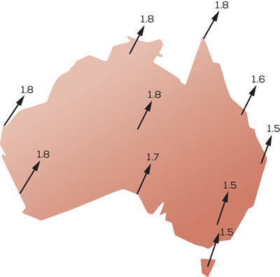
GDA2020 coordinates differ from GDA94 coordinates by approximately 1.5 to 1.8 metres and are more closely aligned with the reference frameworks used by modern GNSS – such as GPS, GLONASS, Galileo and BeiDou.
The standard map projection associated with GDA2020 is the Map Grid of Australia 2020 (MGA2020), a transverse Mercator projection that conforms to the internationally standardised Universal Transverse Mercator Grid system.
The changes are needed because national and global location information systems operate differently, and they are diverging. Australia’s national grid of latitude and longitude coordinates moves with the drift of the continent, like a giant net tied to known reference points on the landscape. Together, these reference points and latitude and longitude coordinates are known as a geodetic datum. Every country has its own datum, and the official Australian geodetic datum since 2000 has been the Geocentric Datum of Australia 1994, or GDA94. The coordinates of features on our maps, such as roads, buildings and property boundaries, are all based on GDA94, and they do not change over time.

There have been significant technology developments recently that provide ready access to accurate positioning systems. It is anticipated that the Global Navigation Satellite System (GNSS) will be capable of providing positioning services with centimetre accuracy in real-time to the mass market on mobile devices. Given that data from GNSS is referenced to a global reference frame, specifically the International Terrestrial Reference Frame 2014 (ITRF2014), it is appropriate that the Australian datum is closely aligned to the same global reference frame.
There are a number of useful references available on-line from Geoscience Australia and the Intergovernmental Committee on Surveying and Mapping. A search for GDA2020 will reveal a list of useful resources, including a series of informative fact sheets.
If you are in Brisbane, 30 October, the ASEG Queensland Branch meeting will feature a talk by Matt Higgins, Manager of Geodesy and Positioning in the Queensland Department of Natural Resources, Mines and Energy on the new datum.