Geoscience Australia is applying specialist geophysical knowledge and capability in the search for missing flight MH370.
Geoscience Australia provides advice, expertise and support to the Australian Transportation Safety Bureau in sea floor mapping (bathymetric survey) and the underwater search.
The data acquired as part of the bathymetric survey has been collected for the sole purpose of finding the missing plane and to bring closure to the families of those on-board. However, as it is some of the first high resolution data available in these areas, it is of great interest to the scientific community and will be released to the public by Geoscience Australia in due course.
The search for MH370 includes a bathymetric survey, providing a detailed map of the sea floor topography of the search area; and an underwater search using scanning equipment or towed submersible vehicles. The information gained in the bathymetric survey is used to build a map of the sea floor in the search area, aiding navigation during the underwater search.
Bathymetric surveys were conducted from May to December 2014, collecting data over 200,000 square kilometres in the search area and producing high resolution maps of the sea floor to safely conduct the underwater search.
Survey vessels undertaking the bathymetric survey used a multibeam sonarmounted on the hull to obtain measurements and produce a map charting the water depth and hardness of the sea floor. High resolution multibeam data acquisition is time-consuming. It is a little like mowing grass, where bathymetry is mapped line by line.
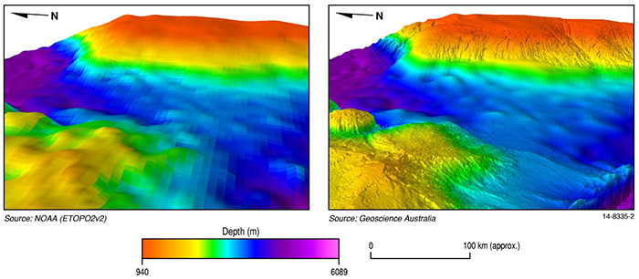
In general, the world’s deep oceans have had little exploration. Previous maps of the sea floor in the search area were derived from satellites and only indicated the depth of the ocean at a coarse resolution, not showing the shape of the sea floor in enough detail for safe navigation of underwater vehicles. These coarse maps provide data at a low resolution of approximately 1500 metres (per pixel), while the recent multibeam bathymetric survey collected data at 40 to 110 metres (per pixel). This newly acquired data is some of the first high resolution data available for these areas.
Find out more via the Geoscience Australia website.